This task combines image understanding, natural language processing and speech recognition. An image analyst currently manually prepares natural language collateral material related to an image. Annotations on the image are also prepared manually. The goal of this image annotation project is to utilize advances in speech technology and natural language (NL) and image understanding (IU) research to prepare image-related collateral more efficiently.
We have been developing a prototype system consisting of two phases. Figure 1 illustrates the system's functionality. Phase 1 consists of automaticly interpretating/indexing images. In this phase, an analyst views an image, and describes the image in spoken language, pointing from time to time to indicate objects or regions in the image. A state of the art speech recognition system is employed in transcribing the input and synchronizing the speech with the mouse input. The text along with the mouse input is used to identify all entities which have been given a label by the analyst. The system output is an NL collateral description and an annotated image. The annotated image consists of (i) a semantic representation of the text and (ii) locations of objects, regions identified in the image. Information is represented such that spatial reasoning, temporal reasoning and other contextual reasoning is enabled.
In the second phase, we provide point and click querying synchronized with speech on the annotated images. For example, the query show all man-made structures to the west of this <click> forest would cause the appropriate areas in the image to be highlighted; each of these could be further queried for corresponding textual information.

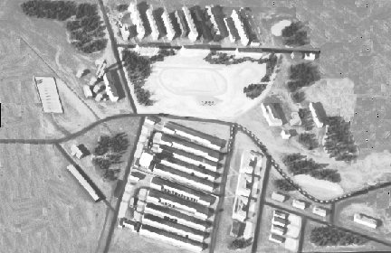
Figures 2 and 3 show show a sample aerial image and its corresponding speech input. The task is to label all objects explicitly named by the analyst in the speech input.

    This image depicts the Sun-yab Military Base and
    Intelligence headquarters which is located in the
    southeastern portion of the country approximately
    25 miles from Nickel City. The size of the facility
    indicates that it can house several battalions.
    The base is divided up into several functional areas.

    There is an S-shaped road (series of mouse clicks)
    running through the entire facility.  We will call
    this RD-1. The main gate to the facility is located
    on the westernmost point of this road. In this image,
    there appears to be a convoy proceeding along this road.

    Area A (use mouse to outline area) is in the
    center of the facility.  It looks like an athletic complex.
    It consists of an oval track and various other buildings
    surrounded by foliage areas. It is bounded by roads on
    the western and northern perimeters. These will be designated
    as RD-2 and RD-3 respectively.

    Area B (click) is the vehicle storage area.  It is
    situated to the southwest of the track and is bounded by RD1
    on the northern border and by roads RD-4 and RD-5 on the
    western and eastern borders respectively.  It consists of
    ten wooden vehicle storage sheds which we will designate
    as VSS 1 through 10. The western part of this area contains
    additional buildings. The multi-story building must be Baldy
    Tower (click).
Figure 3: Speech input accompanying the aerial image shown in previous figure
There are several assumptions we are making in specifying the task and our proposed solution. From the perspective of an image analyst, this approach constitutes a healthy compromise between (i) tedious manual annotation, even when tools such as snakes are provided, and (ii) completely automated (image-based) interpretation. Since the task involves co-referencing image areas with textual descriptions, our system uses the text for dual purposes: co-referencing as well as for assisting image interpretation.
The second assumption concerns the use of preconstructed geometric site models. These have been used effectively in the RADIUS community for registering new images of a known site and subsequently for change detection. Figure 4 illustrates the manner in which text accompanied by mouse clicks are interpreted in both the presence and absence of 3D site models.

Finally, at this point we assume that an approximate shape representation for objects is sufficient for reasoning purposes. We represent objects such as buildings or areas by simple bounding boxes with orientation; polylines are used for roads, rivers. Our system does allow for more exact representations for display purposes.