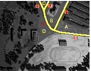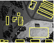
The prototype system demonstrated here is designed to help image analysts annotate aerial images. Mouse input is first used to detect roads and subsequently partition the image based on roads. Next, an analyst describes and identifies salient features in the image (e.g., buildings) via a speech interface. The speech is transcribed, and the resulting narrative is processed by a natural language understanding component which generates visual constraints on the image. This in turn is used by an image interpretation system in detecting and labeling areas, roads and buildings in the image. Finally, facilities to attach additional collateral to objects which have been identified as well as a querying system (taking language and mouse input) have also been provided. Techniques from several sub-disciplines of Artificial Intelligence have been assimilated into this system, including computer vision, natural language understanding, spatial reasoning, knowledge representation and information retrieval. The system is implemented in C and LISP and uses LOOM (ISI/USC) for knowledge representation. The system runs in real-time on a SPARC 20 under Solaris.
Example
Label road segments S1, S3, S5 as Main Street. The Athletic Facility is in the southern half of area D. In the center of this area is an oval running track. The left half of Area D contains the Research Division. In the center of this area are four buildings. Label the L-shaped building as the Advanced Research Institute. Label the large, multi-storied building as Jarvis Hall. This is where most of the administrative offices are located. |
 |
 |